- 注册
- 2012-10-07
- 消息
- 128
- 荣誉分数
- 216
- 声望点数
- 103
冰雨来了
Alerts in effect for Ottawa, ON
Freezing Rain Warning
Issued at 10:55 AM EST Sunday 9 December 2012
Summary
First significant bout of winter weather expected.
Details
A weather system from the American Midwest will head towards Southern Ontario today. Periods of snow or ice pellets will begin in the southwest early this afternoon, reaching Niagara and the Greater Toronto area (gta) to Georgian Bay by late afternoon. A coating of a centimetre or two of snow is likely from Southern Lake Huron eastwards into the gta by early this evening before it changes into freezing rain this evening. The freezing rain will then change to rain. Farther north towards Georgian Bay and also across Eastern Ontario, higher snowfall amounts are likely beginning this evening, where 5 to locally 10 cm is likely. It is highly expected to change to freezing rain overnight and persist into Monday. Motorists are urged to be cautious during this first widespread mix of wintery weather. Untreated roads and sidewalks may become slippery due to the snow and freezing rain. There is a slight risk that regions along the Ottawa Valley including Ottawa may exceed 10 to 15 centimetres of snow. Environment Canada is monitoring this weather system closely and will upgrade the freezing rain warning to a winter storm warning if these higher snowfall amounts become likely.
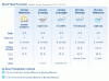