- 注册
- 2007-06-14
- 消息
- 8,234
- 荣誉分数
- 64
- 声望点数
- 178
Scientists map Ottawa quake risk (Map)
Exclusive: Scientists map Ottawa quake risk
By Andrew Duffy, The Ottawa Citizen April 24, 2009
Scientists map Ottawa quake risk (Story)
Scientists map Ottawa quake risk
Data confirm why earthquakes are felt more in Orléans than in other areas
By Andrew Duffy, The Ottawa Citizen April 25, 2009
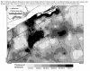
OTTAWA — Earth scientists have produced an earthquake "hazard map" for Ottawa that charts those parts of the city most at risk from seismic shaking........
If you want see the map and story in detail, please click the website link above.
I read newspaper and saw the map is big enough to find where is the location I went find. Unfortunately, from The Ottawa Citizen website, the map is much smaller --- may some one can help and enlarge the map?
Red/orange colour is most risk, and yellow in between safe and unsafe, and 绿色 & 蓝色 is safe. Anyway, two black lines are HW417 and HW416; most risk and biggest red area at right is Orleans; Barrhaven around lablows Greenbank Rd is at safe colour of 蓝色 (it is in the centre of the map); some unsafe orange risk area is along Rideau river; Kanata around Nortel is at 绿色 safe; around Ottawa University is at 蓝色 safe colour; Carleton University is at a small orange risk colour area .
Exclusive: Scientists map Ottawa quake risk
By Andrew Duffy, The Ottawa Citizen April 24, 2009
Scientists map Ottawa quake risk (Story)
Scientists map Ottawa quake risk
Data confirm why earthquakes are felt more in Orléans than in other areas
By Andrew Duffy, The Ottawa Citizen April 25, 2009
OTTAWA — Earth scientists have produced an earthquake "hazard map" for Ottawa that charts those parts of the city most at risk from seismic shaking........
If you want see the map and story in detail, please click the website link above.
I read newspaper and saw the map is big enough to find where is the location I went find. Unfortunately, from The Ottawa Citizen website, the map is much smaller --- may some one can help and enlarge the map?
Red/orange colour is most risk, and yellow in between safe and unsafe, and 绿色 & 蓝色 is safe. Anyway, two black lines are HW417 and HW416; most risk and biggest red area at right is Orleans; Barrhaven around lablows Greenbank Rd is at safe colour of 蓝色 (it is in the centre of the map); some unsafe orange risk area is along Rideau river; Kanata around Nortel is at 绿色 safe; around Ottawa University is at 蓝色 safe colour; Carleton University is at a small orange risk colour area .